WHAT HAPPENED TO WINTER?
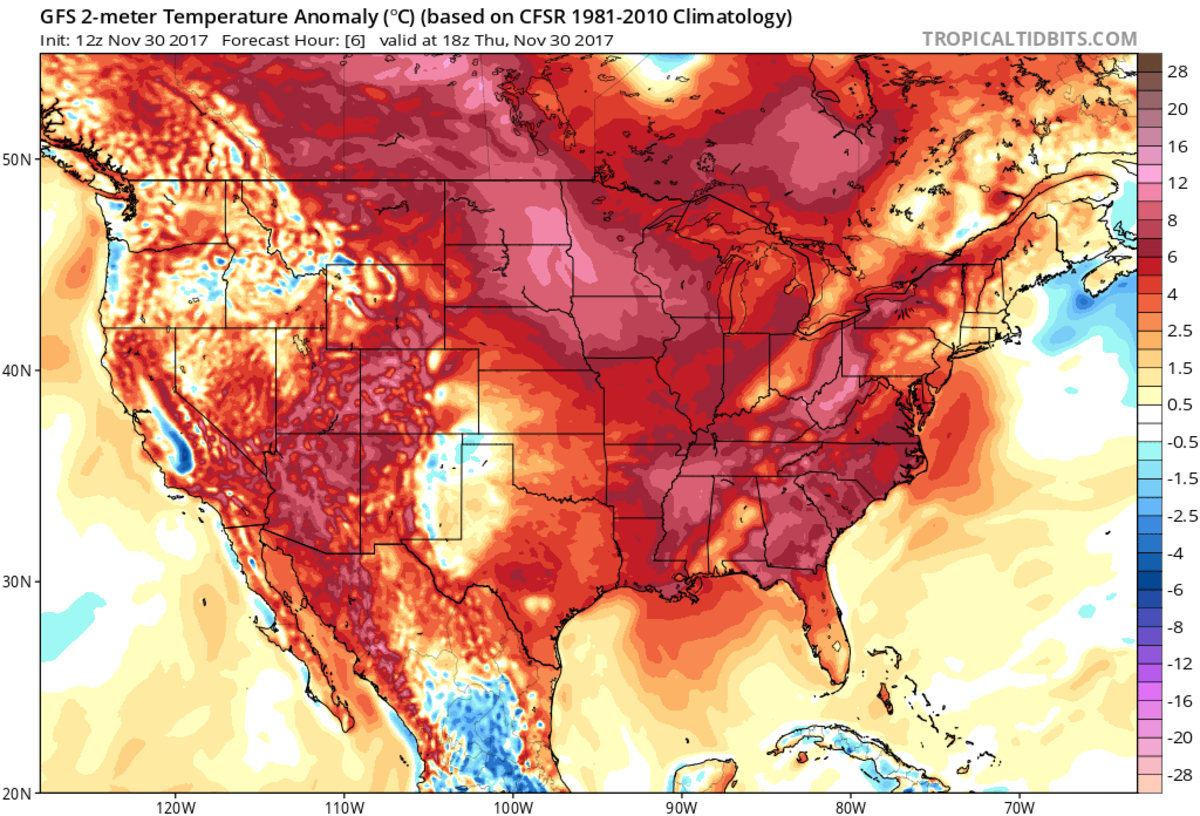
December is here, but warm temperatures are setting records nationwide.
In a season traditionally devoted to snow, a rash of unseasonably warm weather means that, right now in the United States, there's hardly any of it.
A coast-to-coast holiday heat wave means that, on Thursday, the last day of November, just 7.6 percent of the country was snow-covered, about one-third of the typical value over the past 15 years. Over the past seven days, 1,550 record high temperatures have been set across the country compared with just 15 record lows, a 100 to one clip. Nearly every corner of the country is warmer than normal.
In parts of the West, it's actually T-shirt weather: Temperatures in the Rockies, for example, are more typical of mid-June than late-November. On Monday, Denver reached 81 degrees—some 34 degrees above normal and warmer than Los Angeles, Houston, or Tampa, Florida—the warmest temperature ever recorded there during the month of November. On the same day, it was so unusually warm in Salt Lake City that the city broke its record high—at 2:20 a.m. Tucson, Arizona, set record highs all four days of the long Thanksgiving weekend, peaking at 92 degrees on Sunday—the highest reading ever measured there so late in the year.
While the warm weather has stalled the opening of ski slopes and ice skating rinks, it's been a boon for construction crews and in-person retail shopping. In many places, it just didn't feel like the day before December. The seasons themselves are confused.
There's some science to what's happening here. Human-caused climate change is shrinking the duration of winter around the world, with cold days arriving later in the fall and not persisting as long during early spring. Winter is the fastest-warming season for most of the U.S. in part because, as snow packs shrink, darker surfaces like soil and plants are able to retain the sun's energy better.
The onset of La Niña has also helped shift the jet stream northward, making space for warmer tropical air to creep into the Southern U.S.—a pattern that's expected to persist all winter long.
The jet stream shift also means it's been unusually dry lately in most Southern states. Since October 1st, Los Angeles has recorded just 0.11 inches of rain, and rainfall deficits are starting to rack up in Texas, just two months after Hurricane Harvey brought some of the most intense rains in U.S. history. This week, the U.S. drought monitor recorded the biggest one-week jump in "moderate drought" ever measured during the fall and winter. More than 21 percent of the country is now in official drought conditions, which are expected to spread and intensify over the coming months.
The warm weather isn't just confined to the U.S. Parts of Australia, China, and the Arctic are all experiencing similarly intense heat waves. In Greenland, temperatures on Thursday are a whopping 36 degrees above normal.


Geen opmerkingen:
Een reactie posten