Extreme Warming at the Poles this Week — Arctic and Antarctic Temperatures to Rise to 20-30 C Above Average in Some Locations
Human-caused climate change via fossil fuel burning produces a number of stranger things. And some of the weirdest happen to occur in the polar regions of our world.
One of the foremost of these odd impacts is called polar amplification. Under polar amplification, the warming effects of elevated greenhouse gasses are concentrated at the poles. This is due to reduced reflectivity (albedo) from smaller snow and sea ice concentrations, due to the increased intensity of the greenhouse effect in colder and darker regions, and due to increased energy transfer from lower latitudes into upper latitudes due to weakening of the polar Jet Stream.
Over the next week, this kind of polar amplification is predicted to generate very extreme warm temperatures for both poles of our world.
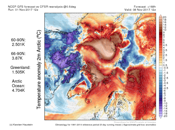
(Warm winds blowing into the Arctic will produce far above average temperatures this week. Image source: Global and Regional Climate Anomalies.)
In the Arctic, temperatures in both Northern Greenland and on the Siberian side of the Arctic Ocean are predicted to hit ranges higher than 20 degrees Celsius above average (36 degrees Fahrenheit) with some readings over Northeastern Siberia striking near the 30 C above average mark by early next week (54 degrees F). This will produce near or above freezing temperatures over both Siberia and sections of the Arctic Ocean near or north of the 80 degree North Latitude line. Overall, temperatures are predicted to average as high as 4.4 C above average for the entire Arctic. A very considerable warm temperature departure consistent with the heightened levels of global warming the world has been experiencing during recent years.
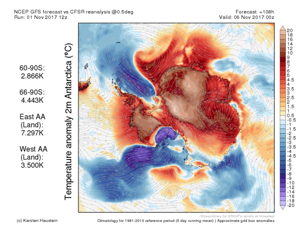
In the Antarctic, where temperature variance should be moderating as austral spring shifts toward summer, the exact opposite is occurring. Very warm temperatures hitting more than 20 C above average are expected to sweep across East Antarctica this week and ultimately cross over to West Antarctica. Above freezing or near freezing temperatures in some coastal regionsincluding coastal West Antarctica and over the Amery Ice Shelf in East Antarctica will accompany far warmer than normal, but still below freezing, temperatures inland.
(Even as the Arctic is predicted to heat up, the Antarctic is also expected to experience much warmer than normal conditions. Image source: Global and Regional Climate Anomalies.)
Overall temperatures for East Antarctic land masses will hit an amazing 7 C above average even as temperatures for West Antarctic land masses rise to 5.1 C above average for later this week.
Primary atmospheric drivers for these warming events are large synoptic warm wind patternsdrawing above average temperatures into both the Arctic and Antarctic. In the Arctic, winds crossing hundreds of miles of warm Pacific Ocean in association with the back side of a high pressure system moving over the Bering Sea will draw these very warm temperatures northward. In the Antarctic, warm winds funneling southward from Australia will reinforce the influence of a strong high pressure dome over East Antarctica even as another strong synoptic warm wind pattern feeds into West Antarctica off the Pacific and Southern Oceans later in the week.
It’s very early for temperatures over parts of Antarctica to be pushing above freezing. And it’s rather late for such similar temperatures to be continuing to invade so far north into the Arctic. So much warmth will have an ongoing deleterious impact to both sea and land ice as well as snow cover. Contributing to the overall pattern of warming and melt we’ve seen for both Antarctica and the Arctic during recent years as global temperatures have risen into a range from 1 C to 1.2 C above 1880s averages.
RELATED STATEMENTS AND INFORMATION:
Links:


Geen opmerkingen:
Een reactie posten