Delving Further into Uncharted Territory: Arctic Sea Ice Greatly Weakened at Start of Spring 2018
The story of Arctic sea ice is one of short term complexity overlying an inexorable long term trend of decline. It has thus been difficult for sea ice monitors to forecast seasonal ice growth and retreat, despite a larger and significant warming of the Arctic.

(New ice has formed north of Greenland following a massive polar warming event last week. This ice is thin and faces the warm up of spring and summer with uncertainty. Sitting over a region that is typically filled with thick ice, it could provide a back-door for melt into the Central Arctic come summer. As usual, weather will play a key role in this year’s melt, despite the undeniable longer term trend of loss. Image source: NASA.)
Undeterred by these facts, a number of key factors stand out in 2018 — following a winter in which the Arctic has suffered considerable warming and related impacts to the ice.
Lowest Sea Ice Extent; Warmest Freeze Season
Today, Arctic sea ice extent is at its lowest levels on record. Volume, is at the second lowest levels ever measured. And this year’s freeze season (October through February of 2017-2018) was the warmest ever recorded (see link below). Taken at face value, these are pretty stark statistics. But they don’t tell the whole story. Not by a long shot.
The Arctic is warming up twice as fast as the rest of the world. It has been doing so since around 2000 when Polar Amplification — the science-based expectation that the poles will warm faster than the globe as greenhouse gas levels rise — really began to kick in. So the present warm peak in the Arctic is on top of a record spate of accelerated warming. In the graphs it looks like a rocket ship taking off.

Air temperatures (at 925 hPa) are a record high for the #Arctic freeze season (October - February, >67°N) in this data set
Graphic: http://sites.uci.edu/zlabe/arctic-temperatures/ …


10 antwoorden109 retweets104 vind-ik-leuks
We should be clear that most of this warming has occurred during winter time. It’s warmth that has softened the ice, thinned it. Produced a big push toward thaw. But like a cup of water with a single cube of melting ice in it will resist surface temperatures above freezing, this thinning and melting has yet to have have a significant impact on summer-time temperatures in the high Arctic. That thinning skein of ice is still doing its duty keeping the Arctic summer close to freezing. But it’s a realistic question to ask — how much longer can it? What happens when the majority of the summer ice is gone?
Such radical warming has also had a number of environmental effects. It is pushing fisheries that rely on cold water northward. It is stressing key species like the Wright Whale, the Polar Bear, and the Puffin. It is causing the permafrost to thaw, which produces a number of environmental feedbacks. Not the least of which includes land subsidence, the release of mercury into the Arctic environment and global ocean, and the slow but rising expulsion of greenhouse gasses long locked away.
Multiyear Ice Has Pulled Away From Shore
The thicker ice floes of yore are now mostly a bare memory. A recollection of past cold blasted away by fossil fuel burning and inexorable thaw. This year, an LNG tanker crossed the thinning ice during winter time. Bearing with it a great load of climate change quickening gas destined to be burned in some nation still entangled by a heat-producing web of gas plants, coal mines, and diesel and gasoline cars.

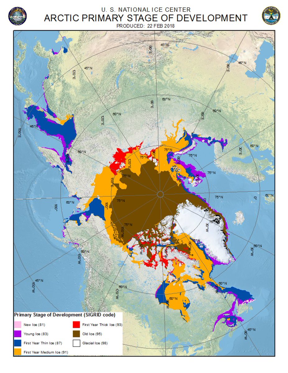
According to the U.S. National Ice Center, this year’s ice (multi-year ice) has pulled completely away from the coast and the Northern Sea Route is dominated by first-year medium (0.7- to 1.2-meter) or first-year thick (1.2- to 2-meter) ice.


0 antwoorden14 retweets6 vind-ik-leuks
The thick, multiyear ice is reduced to a phantom of its former girth and extent. It has drawn back, pulling away from shore. Increasingly sequestered to more and more remote regions. And on the run from the ocean swells, warmer storms, and increasing instances of liquid rain that fall across an Arctic that is facing violent transition.
Increasingly, it huddles closer to Greenland and the Canadian Archipelago. But as we can see in the image at the top of this post, even this region is no longer a reliable sanctuary.
Cold Pole Shift in Forecast — Canada/Alaska Predicted to See Abnormal Warmth
As late winter transitions into early spring, we enter the less certain time of melt and thaw season. During recent years, as warming bloomed in the lower latitudes, the Jet Stream which had slowed and meandered more during winter due to polar warming, snapped back into place. This seasonal flattening and speeding up of the upper level winds tended to harden and deepen the cold pole at the north of our world. Reducing relative temperature variance above normal averages even as melt season advanced.
This created a kind of Dr. Jekyll and Mr. Hyde relationship between winter and summer in which high Arctic winter temps seemed outrageously warmer than normal even as summer snapped back to more typical Arctic averages in the furthest north locations.

(As we enter spring and summer, high Arctic temperatures tend to regress back toward the mean following winter warming. This is largely due to the inertial cooling influence of ocean ice which will tend to keep temperatures closer to the freezing line even as net energy gain is ongoing. Loss of ice would result in the removal of this insulating effect and likely push summer anomalies for the region into the +1 to +5 C range. Image source: Zachary Labe. Data Source: DMI.)
But all is not well. The loss of winter climate norms have done their damage. And the summers, on balance, saw the edge ice retreat a bit further. Saw the boundaries of Arctic cold pull a bit tighter and saw the open, warmer, sunlight-capturing waters advance ever northward.
We don’t know if this return to more normal temperatures for the high Arctic during summer will save the ice from new record lows this year during melt season. But we can track how thaw season is predicted to advance against a greatly weakened Arctic sea ice pack. And this year, the cold pole appears to be expected to shift over the land mass of western Siberia during early March.

(A warm North America, cool west Siberia dipole appears to be developing during early March in the forecast models. If this trend reinforces, it could leave large areas of ice open to early thaw from the Alaskan and Canadian maritime to the Central Arctic. Note that residual energy transfer along ocean zones remains in play in this forecast. Image source: Climate Reanalyzer.)
Meanwhile, on the North American side, abnormal warmth is predicted to advance through Alaska, Western Canada, and the Hudson Bay region.
If this trending location of warm and cool extremes reinforces and holds through melt season start, we can expect the front of melt advance to begin on the North American side as the region near the Kara and Laptev seas resist melt advance longer. Meanwhile, latent warmth over the Bering Sea and Svalbard appear to be set to hold back late season refreeze in these two key zones.
How this weather dynamic plays out will determine if melt season 2018 begins on a record low ramp and how resilient the ice will be to the seasonal thaw that is on the way. We are presently in a situation where a record low start is possible even as reasonable concerns about a potential rapid summer melt progression are presently heightened.


Geen opmerkingen:
Een reactie posten