Climate Denial Crock of the Week
with Peter Sinclair
Arctic Melting as Europe Freezes. Where Where Have I seen this Before? Oh, Yeah Science.
February 26, 2018
Hot north pole: the cold polar air has shifted over to us on the eurasian continent. A result of the polar vortex (which normally fences in the cold air on the pole) getting less stable, as our PhD student Marlene Kretschmer has shown: https://www.pik-potsdam.de/news/press-releases/winter-cold-extremes-linked-to-high-altitude-polar-vortex-weakening …
And, oh yeah, I’ve been bringing you those voices for years now, at this blog, thru these videos.
You’re welcome.
You’re welcome.
Hey, don’t get mad at me.
There is growing scientific support for one of the most provocative and counterintuitive ideas in climate change research, which holds that rapid Arctic warming may be causing colder winters across large swaths of the Northern Hemisphere.
A new study, to be published in the journal Bulletin of the American Meteorological Society,found that a weakening polar vortex, potentially set in motion by the rapidly warming and melting Arctic, has become more common during the past four decades. This results in colder winters across large regions of Europe and Russia, but also occasionally in the U.S. as well.
The study is the first to show that changes in winds in the stratosphere substantially contributed to a mysterious winter cooling trend in northern Europe and Asia, including a region already known for being frigid: Siberia.
The study, written by a group of European and American researchers, found that a weakening in the wintertime polar vortex can explain 60 percent of the observed cooling in Eurasia since 1990. That figure increases to 80 percent if other influences on winter weather, including El Niño events, are also included.
“In winter, the freezing Arctic air is normally ‘locked’ by strong circumpolar winds several tens of kilometers high in the atmosphere, known as the stratospheric polar vortex, so that the cold air is confined near the pole,” said study co-author Marlene Kretschmer from the Potsdam Institute of Climate Impacts Research in Germany, in a press release.
“We found that there’s a shift towards more-persistent weak states of the polar vortex. This allows frigid air to break out of the Arctic and threaten Russia and Europe with cold extremes.”
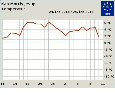
There is open water north of #Greenland where the thickest sea ice of the #Arctic used to be. It is not refreezing quickly because air temperatures are above zero confirmed by @dmidk's weather station #KapMorrisJesup. Wacky weather continues with scary strength and persistence.
The extreme event continues to unfold in the high #Arctic today in response to a surge of moisture and "warmth"
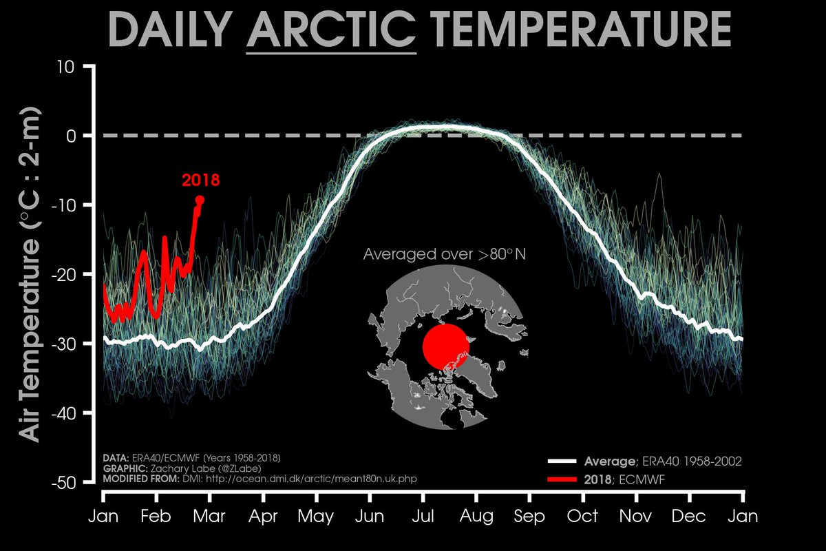
2018 is well exceeding previous years (thin lines) for the month of February. 2018 is the red line. Average temperature is in white (http://sites.uci.edu/zlabe/arctic-temperatures/ …)
The most intense surge of moisture/warmth (relative to average) for this event will be pushing over the North Pole tomorrow. Temperatures projected near 0°C. Meanwhile, brutal cold remains over Europe.
Graphics available from http://cci-reanalyzer.org/wx/fcst/#gfs.arc-lea.t2anom …
The polar vortex probably isn’t quite what you think it is.
It’s not some sort of giant whirlpool in the sky. Nor is it something that can suck you in, like a massive, frigid tornado, rotating above the entire Arctic in a scene akin to the instant freeze of New York City during the film The Day After Tomorrow.
Instead, you can think of the polar vortex as a circular air current that exists at two levels of the atmosphere, one in the troposphere, where most weather occurs, and the other a bit higher up, in the stratosphere. The new study deals with the stratospheric polar vortex.
When the stratospheric polar vortex is strong, the study found, it tends to bottle up the cold air in the Arctic, making northern midlatitudes from Canada to Europe and Eurasia milder than average. A strong polar vortex means that the winds blowing from west to east at high altitudes across the Arctic are more powerful than when the vortex slackens and meanders.
When the vortex weakens, as it did during the infamous winter of 2012-2013, and several winters since, the ultra-cold air can spill out of the Arctic, as if someone opened the door to the planet’s freezer. Not surprisingly, this can lead to cold snaps and snowstorms along the U.S. East Coast, in Western Europe, as well as Eurasia.
Meanwhile, during such episodes the Arctic can be comparatively mild, leading scientists to call such patterns, “warm Arctic, cool continents” setups. These patterns occurred last winter, when several storms brought such mild air to the center of the Arctic Ocean that the North Pole reached near or above freezing for short periods of time.
During the past several years, scientists have been finding that the shape and strength of the stratospheric polar vortex is hugely important for determining what kind of winter weather will dominate large regions of the northern midlatitudes, particularly in Eurasia, which has been seeing a wintertime cooling trend overall.
Temperatures are still breaking records at North Greenland. +6 C (43 F) for a daily high is not just a record for February, it beats the highest temperature observed at this site in March or April as well.
This is roughly 35 C (63 F) above normal for this time of year.


Geen opmerkingen:
Een reactie posten